


Drone Services
Mapping
Orthomosaic Mapping
Topographic Mapping
Landfill Mapping
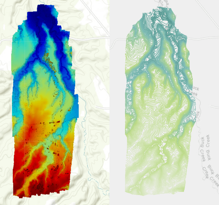
Mine Mapping
SPCC Plans
Analysis
Landfill Mapping
Mine Mapping
Industrial Roof Inspections
3D Site Modeling
Inspections
Industrial Stack
Tower
Railroad
Powerline
Roadway Pavement
Bridge
Solutions
Site Assessments
Site Planning
Marketing


Example Project Experience
- Video Services
- 3D Model for Public Forum
- Industrial Stack Inspection
- 2cm Orthomosaic Mapping
- Roof Inspection for 40 acre site
Below is an example of the high definitioin video services
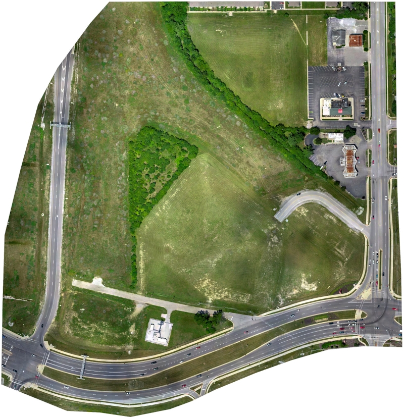
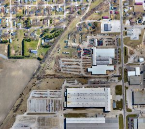
In early July 2018, Wilcox deployed our drone and generated high-resolution aerial imagery, a topographic map and a 3D model used to assist the Town of Speedway Redevelopment Commission in making planning decisions for the project referred to as 2500 North High School Road. The 2500 North High School road project is bordered to the west by I-465, south by Crawfordsville Road and to the east by North High School Road. This currently vacant area of land is a key gateway property for the community of Speedway and is currently in the conceptual design phase for the planned redevelopment. Aerial images from the drone mission were shared and utilized during the public input session held on July 9th. The public input session was well attended, and many Speedway residents shared great ideas for the future redevelopment of the area.
 Video S
Wilcox deploys our drone technology on industrial stack test projects which require personnel to access the stacks directly. Utilizing unmanned systems to review site safety conditions allows for safer working conditions for our staff and better performance on all of our stack testing projects. Flights are pre-planned from the office prior to mobilization and fully autonomous. Flights render a real-time 3D-model while collecting photographic and video documentation for future review.

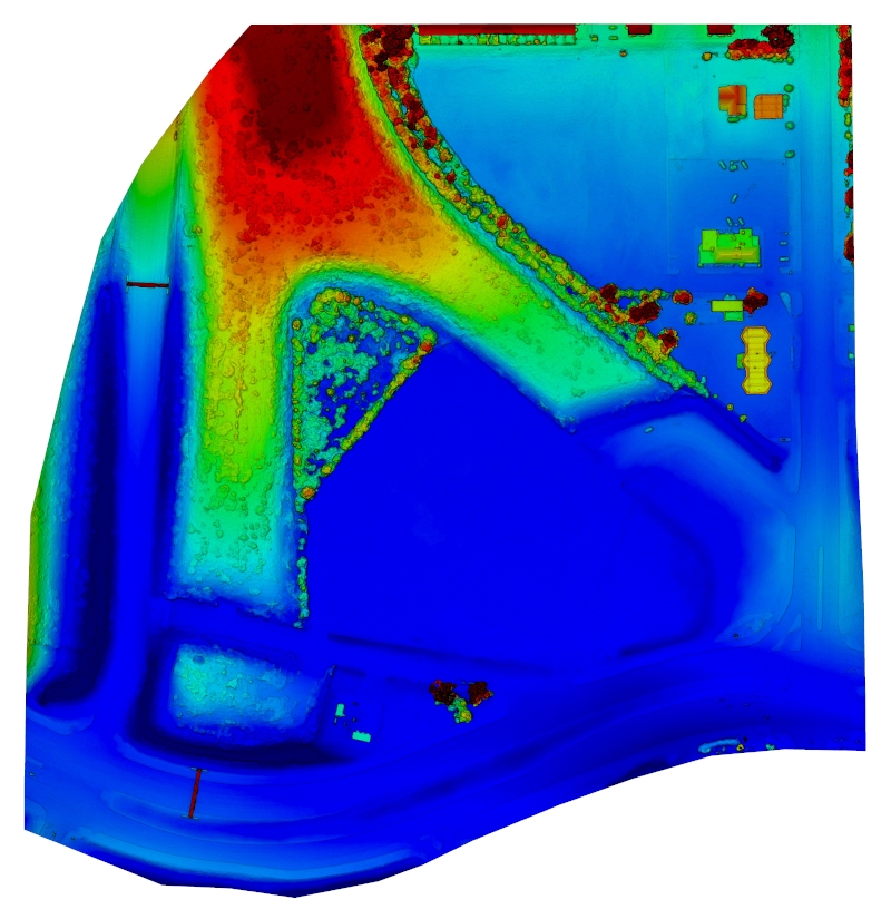
Wilcox deployed our drone to generate an up to date aerial image of an active industrial facility. The monitoring well network extends into nearby residential and commercial properties. Wilcox deployed our drone to autonomously fly the entire 200 acres generating well over 2,000 images. Imagery was stitched together to generate a single aerial image to be used for accurate 2cm mapping purposes.
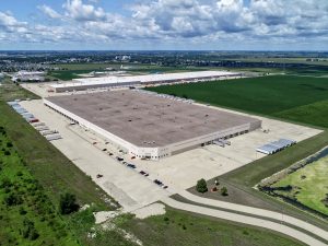
Wilcox performed a drone aerial mapping and 3D modeling project of a 1.5 million square foot warehouse distribution facility in northern Illinois. Traditional inspections typically require access to be managed using cranes and baskets putting personnel at rick and limiting the types of inspections and documentation which can be performed. By utilizing drone technology Wilcox was able to autonomously generate thousands of aerial images for documenting as-built conditions of the roof installation. Once a flight is planned it can be used on subsequent annual inspections reducing costs even more.
Congratulations to Wilcox Project Manager, Craig Eckerle, for obtaining the Part 107 Remote Pilot Certificate.
Congratulations to Wilcox Project Manager, Craig Eckerle, for obtaining the Part 107 Remote Pilot Certificate. The Remote Pilot Certificate is required by the FAA to operate unmanned aerial systems (drones) on a commercial basis. Wilcox anticipates...
How Accurate Are Drone Aerial Maps?
We frequently hear this question from Wilcox clients. To answer, we must first understand how aerial maps are created. Most of today’s aerial maps are created via digital photogrammetry. Photogrammetry is the science of creating maps from aerial photos and has existed...
Congratulations to Wilcox GIS Analyst, Grant Ogden, for passing the FAA’s Part 107 Remote Pilot Certificate examination.
Congratulations to Wilcox GIS Analyst, Grant Ogden, for passing the FAA’s Part 107 Remote Pilot Certificate examination. The Remote Pilot Certificate is required by the FAA to fly drones on a commercial basis. Wilcox continues to grow its drone aerial mapping and...
Wilcox Performs Drone Inspection Services
Wilcox recently performed a drone aerial mapping and 3D modeling project of a 1.5 million square foot warehouse distribution facility in northern Illinois. During the project, Jim Nance provided drone flight training to Wilcox GIS Analyst, Grant Ogden.
Wilcox performs drone mapping and 3D modeling for the Town of Speedway Redevelopment Commission.
In early July 2018, Wilcox deployed our drone and generated high-resolution aerial imagery, a topographic map and a 3D model used to assist the Town of Speedway Redevelopment Commission in making planning decisions for the project referred to as 2500 North High School...
Contact Us
If we didn’t answer all of your questions, feel free to drop us a line anytime.